From Rivers to Railways: The Northern Surroundings of Henrietta Street
StoriesPublished 29 April 2022
By Celina McLaughlin
Unravelling the different layers – of paint on the original walls, of stories, of lives lived – is what I most enjoy about working as a Tour Guide at 14 Henrietta Street.
Today I would like you to follow me outdoors and discover the many layers of history in the surroundings of Henrietta Street. From a hidden river to a forgotten harbour and an Egyptian style railway station, there’s lots to explore in the Dublin of old.
18th Century Dublin
Our visitors sometimes wonder what the local area was like before Henrietta Street, Ireland’s first Georgian Street, was built. So let us travel back to the 18th century and stroll up Henrietta Street together.
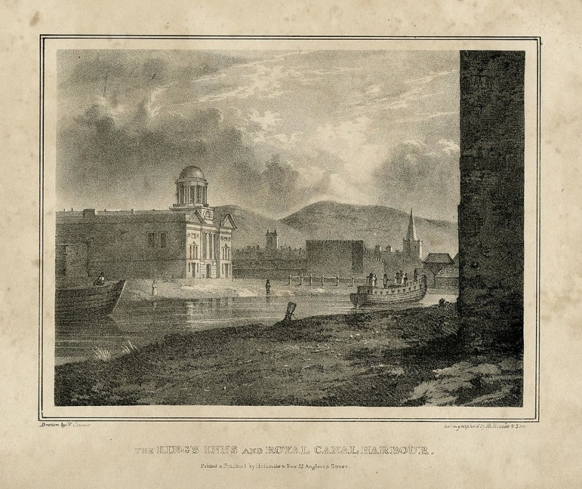
If we turn left out of number 14 and go straight ahead, we will pass under the rear gateway of King’s Inns. This famous building, home to Ireland’s oldest law school, was designed and constructed in the early 1800s, 100 years after Henrietta Street was built. Hard as it is to imagine now, the first residents of Henrietta Street would have a picturesque landscape of fields and orchards, flanked by the river Bradogue, at the top of their street.
Today, this river is 5km long and now flows fully underground. It joins the Liffey close to Capel Street and flows through Grangegorman and the new TU campus. In medieval times, this was the location of Salcock’s Wood, which provided timber for the north city. Further down, in today’s Constitution Hill area, there was a river crossing made out of large slabs. This probably gave the area its name – Broadstone – from Bradogue and Steyn (stone in the Norse tongue).
Life around the River Bradogue
In the 18th century the river was above ground and supplied drinking water, power for the mills, and irrigation for the orchards of a large agricultural area, owned by St. Mary’s Abbey, the biggest Cistercian abbey in Leinster at its time.
In old Irish, Bradogue means “young salmon”, and this was a local delicacy at the time, so much so that some trade apprentices even complained about the salmon-heavy diet.
It’s no wonder then that trade grew in an area where there was plenty of food produce around, and later those markets would become an important employer for tenement residents.
The hilltop position of Henrietta Street – close to the parliament and business core of the city, but raised above the messiness of the markets and city life, and with better air, made it attractive to the nobleman of the 18th century. Its developer Luke Gardiner was well aware of the age-old property mantra, “location, location, location” when he chose the area to build his prestigious street.
A lively transport hub – from harbour to railway
A breakthrough for the rural character of the area came in 1789, with the construction of the Royal Canal, connecting the Liffey to the Shannon. Broadstone was identified as a good point for building a harbour, bringing manmade waterways close to the area of growing markets and courts.
A daily passenger boat service departed from here to Mullingar. Together with many inns and taverns, this lively hub created employment for local people.
A side canal connecting Royal Canal to this harbour had to be built, and it is now the linear Royal Canal Park, connected to the Blessington Reservoir. Originally it was used for storing drinking water for the city, and later supplying water to the local distilleries: Jameson (currently a whiskey visitor centre) and Power’s (now the site of National College of Art and Design). While those places lost their original use, they are still reflected in local street names, such as Royal Canal Bank, and they create a green oasis amidst the inner city.
Broadstone railway station – from train to LUAS
With advances in engineering, the popularity of boats as transport declined, and the great era of railways began in the 1840s. Broadstone became a major train station for the Great Southern Railway company, and it had many uses: from pleasure trips to Galway for the wealthy, to the migration of impoverished workers from the West to Dublin and beyond. It was also used to carry cattle and horses.
Improvements in road infrastructure and another transport revolution led to train lines closing, with the last train pulling into Broadstone Station in 1937.
Broadstone would later become a bus depot, and 80 years later it is a busy rail hub again – with the extension of the green Luas Line that opened in 2017.
A city transformed
The construction of Henrietta Street marked the beginning of a complete transformation of Dublin, and laid the foundations for the city we know today.
Luke Gardiner made his vision for palatial homes for the wealthy a reality with the formation of the street. It set the scene for the fashionable, social northside of the 1700s.
From being a picturesque countryside location where life revolved around the River Bradogue, it became the heart of a new Georgian era of the city.
Next time you’re on Henrietta Street or calling into the museum, maybe you’ll be able to imagine it with lush fields and a river, just before it became the home to the rich and powerful elite of 18th century Dublin.
Main image credit: The King's Inns and Royal Canal Harbour, 1825 - 1830. British Museum, Public domain, via Wikimedia Commons.
Celina McLaughlin

Celina grew up in Poland and in Austria. While studying English, she became fascinated with Irish literature, and it was Dublin's literary connections in every corner that drew her here.
Fueled by a further love of heritage, she qualified as a National Tour Guide and has brought international visitors through all four provinces of Ireland. At 14 Henrietta Street, she enjoys the Georgian era and has been inspired by the courage and the communities of the families that lived in the tenements.
Join a Tour
If you’d like to find out more about the history of 14 Henrietta Street from our team of Tour Guides, why not visit us for a tour.